Monday, October 31, 2011

Crescent City, CA to Fortuna, CA

I became a little weary of the foggy soup of the coastline and I headed inland.  My chosen route was East on California 299, South on California 3, and West on California 36.  California 299 was a lovely mountain ride on the Trinity River National Scenic Byway.  It included an 8-mile conversation with a flagwoman while waiting for construction workers to do something on a bridge.  Because of the license plate on the car, she thought I was from Nevada and I suppose wanted some gambling tips.  I accommodated with the usual--don't take any wooden nickels. This was her fourth year working as a flagwoman.  A career in the making.

The drive back on 3 and 36 was a thrill a second.  For old Simi Valley aficionados, think of 90 miles of Santa Susana pass with Box Canyon road thrown in the middle.  If you look at a map, the Box Canyon part is west of Dismore to the bridge over the Little Van Duzen River.  Left, right, up and down, with no center line and trucks coming the other way.  But I made it.

Earlier I visited the Lady Bird Johnson Grove in Redwoods National Park.  It was an awesome 1.4-mile nature hike through hundreds of huge, tall redwoods--all original growth and all over 200 years old.  They have survived the weather and numerous fires.  Here are some pictures:


Burned Out Redwood
Still Growing

Ferns Growing In Top of
Burned Redwood Stump
Its difficult to get shots of big redwoods because they are so big.  This one was next to the parking lot.  I heard it say to a passing stranger:  "So you think I look bedraggled?  What do you expect putting up with this fog for 300 years and more than a few fires?  And now this incessant shutter-click, shutter-click!"


The best part about seeing these magnificent redwoods is knowing that because they are protected by both the state and federal governments, that barring a nuclear winter, they will be around for a long time to come.

Mileage: 308.  Cumulative mileage: 3, 987.

Sunday, October 30, 2011

Coos Bay, OR to Crescent City, CA

Another day along the Oregon coast, this time along the rougher southern portion.  The weather was overcast, and most of the time it was foggy.  I did see some of the shoreline and I took pictures when I could.  These are examples of basalt outcrops.  The smaller ones are called seastacks and the larger ones are called islands.  There is an Oregon Islands National Wildlife Refuge that consists entirely of these basalt outcrops.


This particular outcrop, located at Bandon, Oregon, is called Face Rock.  Legend says it is the reclining face of an Indian maiden frozen into stone by an evil spirit.  I think my fog-shrouded view gives the rock and the legend the proper effect.

Face Rock

Mileage: 157.  Cumulative mileage: 3,678.

Saturday, October 29, 2011

Newport, OR to Coos Bay, OR

I woke up to overcast, but it cleared by 9 AM.  However, at 1 PM the fog started rolling in.  In between I was able to take in and photography when I think is the most stunning part of the Oregon Coast, although I can't be sure because so far it is the only part I have been able to see clearly and I still have the southern fourth of the coast to go.  The area in question is from Lincoln City south to Newport.  Here are three pictures.

Oregon Coast from Otter Rock Overlook
Otter Rock Overlook
Indentation into Sandstone Cliffs

Basalt Outcrop Known as Gull Rock
Off Cape Foulweather

Cape Foulweather was named by Captain James Cook when he came upon it in bad weather in 1778.  He failed to note the Columbia River on this voyage and thus did not lay claim to it.  Part of the story of why the Columbia River is known as the Columbia River.

Continuing my pursuit of the trail of Guinness Book of World Records I stopped at Depoe Bay, which holds the record of being the "Smallest Navigable Harbor in the World."  These Oregonians really like their records.  Here are the pictures:

Entry Channel to Depoe Bay
Through Bridge Carrying US Highway 101

Depoe Bay
World's Smallest Navigable Harbor

It Even Has Its Own Coast  Guard Station
Driving along the coast, I kept seeing these "Evacuation Route" signs.  I guffawed when I figured out they were for tsunami evacution, thinking of the comparative destructive power of our hurricanes, which are the cause of evacuations along the Gulf Coast.  I also noted that the "Leaving Tsunami Evacuation Zone" signed were on the roadsides at least 300 feet above the level of the ocean.  But then I read my geology book and found out there is a trench offshore parallel to the Oregon and Washington coasts.  Trenches are were earthquakes occur.  Apparently they seldom happen along this trench, but when they do, they are whoppers.  The last such earthquake was about a 9.0 (Richter scale) on January 26, 1700, at about 9 PM.  (I don't know how they know this--I just read it in a book by a professor of geology).  Since they have determined that these mammoth earthquakes occur every 300 to 600 years, the next one will occur any time now or during the next 300 years.  Therefore, we have our tsunami evacuation routes in the Northwest.

One last thing.  There is a famous chain of chowder places along the Oregon Coast known as Mo's.  It is famous not only for its clam chowder, which a lot of people say is the "best", but also because of some famous happenings.  Scenes shot from the main restaurant in Newport appeared in the movie Never Give An Inch, starring Paul Newman and Henry Fonda.  But of more significance to we boomers, at the Otter Rock location, a stool upon which sat Bruce Springsteen on June 11, 1987, is enshrined.  I didn't get to see the stool, but I did get this picture of the place:

Mo's Chowder House
Otter Rock, Oregon
Site of Springsteen Stool Shrine
Mileage:  127.  Cumulative mileage:  3,521.

Friday, October 28, 2011

Long Beach, WA to Newport, OR

Amazing.  This was my first bad-weather day of the trip.  Except that it impaired my views of the coast, it had its own interesting qualities.  The evergreen coastal forests have their own intriguing dimensions in the rain and low clouds.  The wind blew and rocked the car.  The cold spray bit whenever I stopped to take a look around.

The road, US Highway 101, was interesting in itself.  I'm used to this road as a mighty freeway in California.  Up here it is more like a rural road, a US highway circa 1935.  It winds and weaves.  There is virtually no shoulder.  The road is sometimes rough, I suppose from too many logging trucks and an old-style road base.  The traffic is light, but its a bit scary where you're approached by a car that has not turned on its lights.

I started from Long Beach, Washington, which claims, chamber-of-commerce fashion to be the longest beach in the world.  I'm not of a mind to test the claim, and instead head for Cape Disappointment on the northern edge of where the Columbia River meets the sea.  Since 1856 it has had a lighthouse to mark its location for mariners attempting to cross the Columbia River bar.  They first attempted to construct a lighthouse at this location in 1853, but the ship carrying the building supplies was lost on the bar.

The Columbia River bar is the area's most interesting feature, in my opinion.  It is where the current of the Columbia River dissipates as its reaches the ocean.  It is a pile of sandy sediment about six miles wide (perpendicular to the river flow) and three miles across.  It is caused by a river current of 4 to 7 knots meeting the incoming and diagonal flow of the ocean and tidal currents.  Waves across the bar can be up to 40 feet high.  Unlike other major rivers that dissipate their flow through a delta, the Columbia River focuses its flow "like a fire hose", which renders its force a constant threat.  Jetties were built at the turn of the 19th century to anchor some of the out-flowing sediment and to regularize the channel, but the bar remains a potent force.

The bar was a major impediment to the establishment of rival claims to the Oregon Territory in 1792 by American captain Robert Gray and British Captain George Vancouver.  After scouting the location for several days and waiting for proper tidal conditions, Gray crossed the bar and entered the Columbia River in March, 1792.  He named the river after his ship, the Columbia Rediviva.  Vancouver deemed his lead ship, Discovery, too large to cross the bar and instead dispatched a smaller ship, the Chatham under Lt. William Broughton.  Gray went 14 miles inland, while Broughton went as far as the Columbia Gorge near Multnomah Falls.  Both made claims to the land.  Vancouver refused to recognize Gray's name for the river and instead declared it to be the Oregon River.  This all ended up being academic, as the Treaty of Ghent ending the War of 1812 gave the territory to the United States, and the river forever after has been known as the Columbia.  Much of this history and some outstanding exhibits and videos concern the bar are found in the Columbia River Maritime Museum in Astoria.

The highlight of my drive down the Oregon coast to Newport (other than the perspective indicated above) was a visit to the D River in Lincoln City.  It is claimed to be the world's shortest river at 442 feet long, beating out the Roe River in Great Falls, Montana.  Having seen both rivers, the Roe is both more beautiful and more impressive.  The D River flows from Devil's Lake to the Pacific Ocean.  The Roe River flows from Giant Spring to the Missouri River.  Obviously, neither looks at all similar to the Columbia.  Here are my photos of both rivers.

D River, Oregon:


Roe River, Montana:


Julie said to make sure I saw Haystack Rock at Cannon City, Oregon.  So I did:


Mileage: 174.  Cumulative mileage: 3,394.

Wednesday, October 26, 2011

Pendleton, OR to Troutdale, OR


My first big event of the day was a stop at the Mill Store at Pendleton Woolen Mills in, where else, Pendleton, Oregon.  As I told the sales clerk, "When I was in college all of the guys from Portland had Pendleton shirts and I decided I was going to have one.  So here I am, nearly 50 years later, buying myself a Pendleton shirt, and at the mill store, no less."  At $105 for something scratchy, it was a bow to history and memory rather than necessity, but at least in Oregon I didn't have to pay sales tax.

Beyond that I drove along the upper Columbia River Gorge toward Portland.  I decided I would get an early start tomorrow and drive back up the Gorge, particularly since I planned to buy a new camera to replace the one that failed several days ago (thus the reason why no pictures for several days).


Mileage: 135.  Cumulative mileage: 2,895.

Tuesday, October 25, 2011

Baker City, OR to Pendleton, OR

Hell's Canyon of the Snake River.

Snow flurries in the mountains.

Mileage: 352.  Cumulative mileage: 2,760

Monday, October 24, 2011

Baker City, OR

I stayed in the Baker City area today to spend time at two museums.  One was the Oregon Trail Regional Museum, which is a local history venue in Baker City.  It was nice, but not much on the Oregon Trail.  I did find out that the founder of Airstream Trailers, a fellow named Byam, was born in Baker City.  The highlight was an extensive collection of rocks and minerals that had been put together by two sisters over a period of 34 years.  It was very nice and very informative.

The second museum was the National Oregon Trail Interpretive Center, which was an extensive treatment of the history and culture of the mid-19th century migration over the 2000-mile Oregon Trail.  It was very nicely done with excellent displays and dioramas.  The center is on Flagstaff Hill, which overlooks a portion of the tracks of the Oregon Trail.

Mileage: 133.  Cumulative mileage: 2,308

Sunday, October 23, 2011

Bend, OR to Baker City, OR

Today's trip involved heading East from Bend, in central Oregon, to Baker City, which is both astride the old Oregon Trail and the gateway city to Hell's Canyon on the Snake River.

First about Bend.  It has become one of the most attractive cities for retirees, which is a bit of a surprise since it lies on sparsely-treed volcanic ground and about 175 miles from Portland, the nearest large city.  Its major industry is tourism due to its closeness to the High Cascades.  Mount Bachelor, a major ski resort, is 25 miles to the West.  Its third-largest employer (with 1,400 employees) is Les Schwab Tire Centers, which operates over 400 retail tire stores in eight Western states.  Bend has the corporate headquarters.  The largest employer in the area is the local medical center.

Bend was a leader in the housing boom of the aughts, and has suffered in the aftermath of the bust.  However, by outward appearances it looked pretty prosperous to me.  That it, everything looked California-like new.  The statistics say housing prices have dropped 40 percent and unemployment is in excess of 12 percent.  Due to a lack of major industry, it looks to me like Bend will need to appeal to retirees to save itself.

Heading East I entered Ochoco National Forest.  I decided to hit some of the back roads, and I was vain enough to think I had a route scoped out.  I've been having great fun wandering the national forest dirt roads in my rental car over the past few days.  That was until I hit "Vowell Trail"  On the map it looked like a through road connecting to West Branch Road and on back to US Highway 26.  For all I know Vowell Trail may go through, but if it does its more trail than road.  By the time I turned around it was down to two tracks with a high center ridge heading into a bog.  I finally made it out after descending another two-track path for a few miles and then ignoring a no-trespass sign at the edge of the national forest.  (I declared a personal "emergency" to avoid a sense of lawless behavior).

While on my dirt-road trek, I came across the remnants of an extensive forest fire, which burned at least 5000 acres.  It happened in August, 2008, and even now there is little sign of new vegetation.  Here are a couple of pictures of the eerie sight.

Ochoco National Forest
Fire Aftermath

Ochoco National Forest
Fire Aftermath

The highlight of the day was the John Day Fossil National Monument.  It is the most extensive discovery region for mammalian fossils in North America.  The period covered by its fossil beds range from 55 million years ago to 7 million years ago.  The extensive beds are attributed to the recurring volcanic activity in central and eastern Oregon, which has periodically generated volcanic ash mudflows that instantly buried and  preserved plants and animals, both living and dead.  The monument visitors center has an excellent representative collection of these fossils, identifying the locations and geologic periods in which they were found.  The quality of the exhibits is as good as any in a major natural history museum, and is by far the best display I have seen at a visitors center.  Here is an example:

John Day Fossil National Monument Museum
Exhibit from Mammal Quarry
Circa 40 Million Years Ago
The geologic features of the area are also important.  All but two of the fossil periods lie below the flood basalt that occurred 15 to 17 million years ago.  The flood basalt is seen on the horizon as a black cap on ridge tops, such as the one below.

John Day Fossil National Monument
Horizontal Flood Basalt Cap

I have been operating on the theory that the flood basalt resulted from an asteroid that impacted in southeastern Oregon 17 million years ago.  The signage at this location attributed the flood basalt to eruptions of the Yellowstone hot spot at about the same time.  Because the North American Plate has been moving westward, the hot spot was beneath what is now the Washington/Idaho border at that time.  According to this theory, the hot spot spread flood basalt into the monument area at least 17 times, at an estimated once every 8000 years.  The conical peak on the left side of the above picture shows evidence of the numerous flood basalt flows.

Now, who was John Day?  A noted explorer?  A renown geologist?  A farmer who stumbled on the fossils? None of these.  He was a fur trapper who traveled to Oregon country in 1812.  The most noteworthy thing that happened to him was that he was robbed and stripped naked by Indians near the point where the river that bears his name enters the Columbia River.  He was later in route back to St. Louis in the company of other trappers when he went mad and was left behind in the general area of what is now the John Day River.  He trapped  in the area for the next eight years and died in 1820.  Both the town of John Day and the national monument incorporated his name because that was the name of the river.  Very strange.

Mileage: 255.  Cumulative mileage: 2,175.

Saturday, October 22, 2011

Klamath Falls, OR to Bend, OR

I traveled today through a venue of volcanic residue.  All landscapes had a volcanic origin, but ultimately that's the case of all rock, since sedimentary rock (except, perhaps, for limestone) is made up of eroded igneous rock, and metamorphic rock is re-heated igneous and sedimentary rock.  However, this volcanic rock is more immediate and unchanged from when it appeared from the magma below the surface.  Most of what can be seen came into being in the last 20 million years--much of it in the last two million years--too little time for erosion to result in compressed sediments that are then uplifted by plates crashing together.

The major feature on today's drive was Crater Lake, a national park since 1902.  It was formed with the 10,000-foot Mount Mazama exploded 500,000 years ago.  The explosion, from multiple vents, emptied the magma pool under the mountain, and the top of it collapsed, forming a cauldron (not a crater) six miles across.  The cauldron, empty of magma, cooled and gradually filled with water.  The resulting lake is an average 1,148 feet deep and has a maximum depth of 1,943 feet.  Apparently its current level is an equilibrium between accretion and evaporation and seepage because the lake level varies no more than three feet from year to year and season to season, and it has no drainage outlet.  The lake never freezes over and its temperature near the surface stays at about 38 degrees Fahrenheit.  Scientists have found hot spots 1400 feet below the surface that are at 66 degrees Fahrenheit.  It is also deemed the purest lake in the world, with clarity down to 142 feet below the surface.

Crater Lake with Top of
Wizard Island in Foreground

Banks of Cauldron Around Crater Lake

Wizard Island in Crater Lake
Wizard Island is a cinder cone that formed in the cauldron of Mount Mazama after Crater Lake had come into existence.  There is a boat tour that stops off at Wizard Island, and hikers can climb to its summit, which  is 767 feet above the lake's surface.

On the north side of the Crater Lake cauldron is an area called Pumice Desert, which consists of rhyolite ash that was emitted from Mount Mazama.  Because pumice is highly porous, the area does not retain water and very few plants have been able to grow on it.  Hence, the desert-like appearance at an elevation above 5000 feet.

View to North from Crater Lake
Showing Pumice Desert

Pumice Desert
Mileage: 203.  Cumulative mileage:  1,920.

Friday, October 21, 2011

Weed, CA to Klamath Falls, OR

I left George and Wilma's ranch and headed for Lava Beds Volcanic National Monument, on the Modoc Plateau.  This involved curving around Mt. Shasta from the south and the east, giving me more views of the majestic mountain.  The geologic structure of the Modoc Plateau consists almost entirely of flood basalt flows and cinder cones.  The first major flood basalt flows began about 17 million years ago and are believed to have been triggered by an asteroid or comet falling somewhere in Southeast Oregon.  The asteroid or comet created a crater that penetrated several kilometers down to magma in the Earth's mantle.  The reduced pressure on the magna caused it to expand and heat up, causing the crater to collapse and forming a much vaster caldera.  This magma lake periodically emitted flows of basalt lava that over the next two million years covered much of Eastern Washington, Eastern Oregon, parts of Idaho and Nevada, and the Modoc Plateau in the Northeastern corner of California.  Since then, there has been additional volcanic activity that has covered much of the great flood basalt with additional volcanic material. 

Lava Beds National Monument is located in part of a huge shield volcano known as the Medicine Lake Volcano.  It is part of the High Cascade Range, and is the largest volcanic by volume in the range.  A shield volcano generally has a large size and a low profile, and is usually built from fluid lava flows.  It gets its name resembling a warrior's shield.  The Medicine Lake Volcano does not have a since vent at its center.  Rather, it has had numerous vents and has produced many lava flows over the past two million years, and it is still considered to be active.  Contained within the shield are quite a few cinder cones.  The major attration of Lava Beds are caves consisting of basalt tunnels through which the fluid lava flowed.  As the lava flows from the vent, it cools as it comes in contact with the ground and the are.  The surface of the flow hardens, forming the tunnel.  The hotter lava in the center remains liquid and continues to flow, extending the tunnel until the lava has cooled enough to stop its flow.  The tunnels can be miles long, though most are measured at a few hundred yards from the vent.

Mileage:  175.  Cumulative mileage:  1,717.

Tuesday, October 18, 2011

Mendocino National Forest, CA to Redding, CA

There is something invigorating about working out a rental car on mountainous dirt roads.  "Let's see what this baby can do" invigorating.  Okay, I thought about more than I did.  And all I've got to show for it is a very dirty car.  But driving 30 miles up and down over narrow dirt roads was quite an experience.  It reminded me of my childhood when cousin Tom or cousin Jack would take us kids on drives in the farm's Jeep up in the hills around Hemet, California.  Hang on and scream.

Mendocino National Forest consists of more of the Coast Range, which means jumbled Franciscan formation sedimentary rock.  There was some serpentinite but not much granite.  The elevation rises to 6000 feet in a couple of peaks, but mostly it is 2000 to 3000 feet.  The serpentinite is an indication that I am near the east side of the fault area.  According to geologists, the serpentine, a metamorphic rock, is at the base of the North American Plate in this region.  As the Farallon Plate and the Pacific Plate subducted below the North American Plate, the serpentine ridge was the edge underneath which the descending plates passed.  Serpentine is well-suited to be an edge material because it is both extremely hard and "slippery".  I guess that means it has a relatively low coefficient of friction. The primary mineral in serpentinite is talc  Its slipperiness has given it the common name of soapstone.  It is the official state rock of California.  The distinctive feature about serpentinite is its greenish color, which makes it very distinctive and attractive.  Its surface occurrence is spotty because it is subject to exposure only where the edge of the North American Plate was thrust upward.  Mostly I could see in road cuts.

Leaving the national forest, I traveled across the Great Valley, which is flat expanse of sediments laid down from erosion of the Coast Range to the West and the Sierra Nevada to the East.  The primary river is the Sacramento, though with the extensive amount of diversion for irrigation, it doesn't look like much.

An unusual feature in the middle of the valley near Yuba City are the Sutter Buttes, which rise about 2000 feet above the floor of the valley.  They are volcanic in origin, but geologists can't figure out how they arose. One theory is that they are a southern extension of the Cascade Range, which includes Mt. Shasta and Mt. Lassen.  But there seems to be too great a space between Mt. Lassen and the Sutter Buttes where there is no appearance of volcanic activity to make a connection.  Another theory is that they are part of the Coast Range volcanic activity.  The divergent age and composition of the buttes from the other formations impairs the validity of either theory.  For now, they stand alone, and have the dubious distinction of being the shortest mountain range in the world.

The first thing about Lassen Volcanic National Park is that it is high up.  You have to pass through a lot of the adjoining national forest to get to Lassen.  Yet the forest in the park is different.  The southwest part of the park is a vast caldera of a prior volcano, Mount Tehama.  The rock of the entire park is various kiinds of igneous, or volcanic, rock.  Lassen became a national park in a most spectacular fashion.  On May 22, 1915, Lassen Peak erupted, sending a cloud of ash four miles up into the atmosphere.  Less than a year later, Congress made it the 13th national park.  It was the last volcano to erupt in the lower 48 states until Mt. Saint Helens erupted on May 18, 1980.  Lassen is classified as active and is expected to erupt again, though probably not for several hundred years.  Lassen Peak began forming about 27,000 years ago.  It is classified as a dome volcano, which means it develops a thick lava that rises and increases the size of the peak.  Only a small amount of the lava pours from the top and down the sides.  The 29-mile road through Lassen Park reaches a height of 8,512, the highest road in the Cascade Range.  The park had only a few visitors when I was there, and it will close soon when the snow starts to fall.

Mileage: 340.  Cumulative mileage: 1,278.

Monday, October 17, 2011

San Francisco, CA to Mendocino National Forest, CA

After dropping off Julie at the airport, I headed out to explore the San Francisco Bay area.  As is well-known, the San Andreas Fault passes straight up through the San Francisco peninsula and heads northward out into the Pacific Ocean.  The fault is expected to extend over the next fifteen million years up the coastline to the Aleutian Islands off of Alaska.  For now it occupies a deep valley up the center of the peninsula along which Interstate 280 has been laid.  While it is generally a fool's enterprise to try to detect geological features in an urban setting, the fault line with its man-made lakes is hard to miss.  While there is no major crevasse in which to fall, the sides are steep and the rock formations are different.  On the west side is Francisco formation sediment and on the east side is Salinian block granite.

My next place of interest was Napa Valley, which also has an interesting geological history, though that is not its current primary claim to fame.  Napa Valley has been the second most popular tourist attraction in the state because of its wineries.  Julie and I spent a few weekends visiting the Napa Valley wineries while I was stationed at Mare Island Naval Shipyard in nearby Vallejo.  That was in 1971 and 1972, so it has been awhile.  It surprised me how little Napa Valley had changed.  I had expected to see something like Branson, Missouri or Myrtle Beach, South Carolina, with endless tourist shops and entertainment venues.  The only accommodation I saw to the high popularity is that the single highway, California 29, has been four-laned halfway up the valley to Yountville.  There are more wineries, and their tasting facilities are more elaborate, but the ambiance of the area is little changed.  I was there on a Monday, so I didn't experience a weekend crowd.  But I don't think even that would have transformed sedate nature of the area.  There was no family-oriented entertainment places.  The only enterprises center around the wine culture--eating and drinking and watching them grow.  There is a Napa Valley Wine Train, but I didn't see it.

I spent the night primitive camping in Mendocino National Forest, about 50 miles north of Napa Valley.

Mileage: 241.  Cumulative mileage: 938.

San Luis Obispo, CA to San Francisco, CA

We left Mom and Dad, carrying seven bottles of wine furnished by Dad, and headed back up through the Coast Range to San Francisco.  I decided on a detour onto California Highway 25, the "Airline Highway."  No explanation found for the nickname.  It travels northwest from a point east of San Lucas to Hollister and on to Gilroy.  The attraction is that it follows the San Andreas Fault.  That was a bit of a disappointment.  We were hoping for a deep crevasse where we could dare each other to jump in, as in "if you really love me you'll . . . ."  No crevasse.  In this area the fault is a creeping fault, which means it moves continuously at a rate of about three-tenths of an inch per year.  The sides of the fault don't come into complete contact and don't build up stress, and thus there are no earthquakes in this area.  So there are just gently rolling hills with a small valley in between.  The only traffic was ranchers checking their cattle and motorcyclists out for a ride.

The other attraction of Highway 25 is Pinnacles National Monument.  It was one of  three national monuments designated by President Theodore Roosevelt in January 1908, along with Grand Canyon and Muir Woods.   If you look at a map it looks like you can drive east on state road 146 from US highway 101 through the monument to highway 25.  No go.  The road stops about two miles from the entrance on the west side and about four miles from the entrance on the east side.  The other problem is you can't see the rhyolite pinnacles from the road or parking lots.  You have to hike at least a couple of miles, which wasn't on our itinerary.  Pinnacles consist of a volcanic field that erupted about 23 million years ago.  It is located west of the San Andreas Fault, so it has been moving northwest on the Pacific Plate.  The fault itself passed through the volcanic field, and the other part of it is about 200 miles southwest near Lancaster, California, on the western end of the Mojave Desert.  That little factoid was used as part of the evidence to establish the theory of plate tectonics.

We also had dinner with Hub and Jacob at the Chenery Park Restaurant in the San Francisco neighborhood of Glen Park, near Daly City.  Good food and delightful conversation.  Julie flies home on Monday and I continue on to Northern California and Oregon for a couple of weeks of trekking.

Mileage: 285.  Cumulative mileage: 695.

Saturday, October 15, 2011

Pensacola, FL to San Luis Obispo, CA

Julie and I are on a trip to California, primarily to see Mom and Dad.  We are staying at Shell Beach, which is South of San Luis Obispo and is part of Pismo Beach.  We are staying in a motel on the bluffs overlooking the Pacific Ocean.  The scenery is exquisite and is similar to the fabled Big Sur area to the North.

The cliffs are part of the Franciscan formation, which is a jumble of rocks resulting from the Pacific tectonic plate sliding under the North American plate.  Because most of the rock is sedimentary, you can tell its horizontal position when it was laid down.  The process of subduction has resulted it this sedimentary rock being scraped off and left, helter-skelter, in and above the trench and forming the mountains of the Coastal Range in California.  As I said, you can tell what was the horizontal position of the sediment when it was laid down.  Now the sedimentary rocks go at all different angles, with some slabs very close together but at 90 degrees to 120 degrees different in angle.  It makes for a very confusing sight.

The onslaught of the Pacific's pounding surf is eroding the cliffs in dramatic and scenic fashion.  The sedimentary rock is rather loosely bound and contains lots of gravel, so it breaks apart fairly easily.  Dad tells me that California now prohibits most efforts to impose barriers to stop erosion, so the cliffs will continue to gradually be consumed by the ocean.

We had quite a day on Saturday with Mom and Dad.  We went to the Pismo Beach monarch butterfly grove, a rural retail site-cum-petting zoo called the Apple Barn, and two central coast-area wineries.  In all we were on the go for about five hours.  I thought that was quite a feat for 89-year-old Dad and 87-year-old Mom, and I was the one who cried "uncle" and called it a day.

The monarch butterfly grove had some butterflies, but not a lot.  Its relevance is that it is a winter sanctuary site for monarchs from west of the Rockies.  Monarchs east of the Rockies migrant to a particular region in Mexico.  Those west of the Rockies migrate to the California coast.  This grove in Pismo Beach consists of eucalyptus trees--probably no more than a couple hundred trees, and can hold millions of monarchs in clusters on the branches.  Scientists don't know exactly why they cluster.  A logical assumption is that they do so to withstand the cold, but apparently they have also been known to cluster in warm weather.  The normal life cycle of a monarch butterfly is about six weeks, so several generations pass between winter migrations, yet they always arrive at the same place.  The monarchs that arrive for winter go into a state similar to hibernation, and they survive in this way for up to eight months, then emerge, lay their eggs and die, and their children then make the summer migration back to the Rockies.

Mileage: 410.

Wednesday, September 28, 2011

Northern Virginia

I took a day off from my museum trek to take in some countryside in Northern Virginia.

My first stop was the Manassas National Battlefield Park.  Two civil war battles were fought over the same ground, though the site was mostly coincidental, and following both battles, both sides retired from the battlefield.  In both battles, Confederate General Thomas 'Stonewall' Jackson played a key role.

The first battle occurred in August 1861, and was the first major battle of the war.  Jackson took up a position on the back of Henry Hill and held off the Union offensive until reinforcements under General Joe Johnston arrived and turned the battle into a Confederate rout.

View of Henry Hill, First Manassas Battlefield
Looking South Toward the Confederate Position
Stone House at foot of Henry Hill
Used by Union forces as a Field Hospital
In Both Battles
Stonewall turned the tide in the First Battle of Manassas and he started the Second Battle of Manassas, thirteen months later.  A couple brigades of Union soldiers just happened to be marching back to Washington when they came within range of Stonewall's artillery.  After he had them stopped, he led a charge.  But the Union soldiers fought back, and the fighting ended at nightfall in a bloody draw.  General Pope, the Union commander, spent the next two days underestimating the Confederate strength, sending waves of infantry against the rebel positions.  But Stonewall wasn't alone, as Longstreet had arrived and was actively involved with his corps.  The final day of battle involved an assault by 8,000 Union troops under General FitzHugh Porter, which ended in defeat to an overwhelming Confederate force at a place called Deep Cut.  After the battle was over, General Pope looked around for a scapegoat, and had General Porter court martialled for insubordation, failure to obey orders, and dereliction of duty.  Porter was convicted and drummed out of the Army.  Porter spent the next twenty-six years trying to salvage his reputation, and he was finally reinstated in 1889.

My second stop was at Great Falls Park, which is on the Potomac River northwest of Washington.  It is noted for its cascading waterfalls that drop the river 76 feet in about a half mile.  A canal was built around the falls in 1785, and it operated until 1828, when it was replaced by the Chesapeake & Ohio canal.  In 1906, a light rail system was laid from Georgetown to Great Falls, and an amusement park was built at the falls.  Congress enacted a law establishing the George Washington Memorial Parkway in 1930.  A provision of the law called for the eventual inclusion of Great Falls Park in the parkway.  The National Park Service finally acquired the park in 1966.  Here are pictures of the falls:


Herb, grab your kayak and get to work.

Mileage: 112.  Cumulative mileage: 1,310

Tuesday, September 27, 2011

Washington, DC: National Museum of Natural History

Natural history museums focus on three major themes:  Rocks (Earth), Living Things (Plants and Animals, including Fossils), and Human Culture.  The emphasis at the Smithsonian National Museum of Natural History is on Animals. Almost all of the main floor consists of displays of fossil bones of dinosaurs and mammals, alone with taxidermy models of just about every bird, fish, amphibian, reptile and mammal known to exist.  On the other hand, with the exception of a well-known Human Origins exhibit, human culture gets relatively little attention.  That was all right by me because I wasn't interested in either the living things or the cultures.  I was interested in the rocks, and I spent most of ten hours over two days pouring over those exhibits.

My interest in rocks is a follow-on to my reading the textbook Historical Geology referred to in a prior post, as well as my following along in the book series Roadside Geology on my recent trip.  I found I knew quite a bit about much of what was on display.  But there were clearly areas of new interest.  I spent the first day mostly on viewing the minerals and gems in the National Gem Collection.  The pride of the show is the Hope Diamond, a 44-carat blue diamond that was gifted to the people of the United States by jeweler Harry Winston in 1956.  The origin diamond, weighing over 100 carats, was found in India in the 1600s.  Among its owners was the French queen Marie Antoinette.  It was stolen during the French Revolution in 1792 and remained hidden for 20 years, turning up in London the day after the French statute of limitations on the theft had expired.

Most of the minerals on display, and most of the collection, are the result of three gifts of private collections, two of them in 1926, and the other one (I think) in 1894.  The most dramatic donated collection was that of Washington Roebling, the builder of the Brooklyn Bridge.  Many of the mineral finds appear to be the result of mining activity.  Most of the high-end gems in the collection are the result of individual gifts.  The museum has an ongoing program, funded by a foundation set up by Tiffany, Inc., to acquire additional and unique gem and mineral specimens.  The nice thing about a collection like this is that it saves the rest of us from having to be collectors.  You get a hankering to see "your" gem collection, and you just wander over to the second floor of the National Museum of Natural History and there it is.

There is an outstanding display about meteorites.  Study of meteorites has been used to determine the composition of the early solar system, and to evaluate the results of impacts of celestial bodies such as asteroids and planets.  Scientists used the study of moon rocks recovered by the Apollo astronauts to determine that the Moon resulted from the glancing collision of a Mars-sized planet with Earth about 4.5 billion years ago, with the debris from collision going into orbit around Earth and coalescing as the Moon.  When originally formed the Moon was much closer to Earth that it is now, and apparently it is still gradually moving away from Earth.

Sunday, September 25, 2011

Bee Rock Campground, KY to Silver Spring, MD

Sunday became an enjoyable day of driving the hilly coal country of Eastern Kentucky and Southern West Virginia.  The focal point of this area is Hazard, Kentucky.  The town is located in Perry County, and the town and county are named after Oliver Hazard Perry who tweeted during the War of 1812:  "We have met the enemy and they are ours."  Meaning, I guess, that he beat Romney in the umpteenth Republican debate.

The coal in this area is abundant, and derives from the Pennsylvanian Period, 318 million to 299 million years ago. During this period in this area swamps proliferated, resulting in oxygen-deprived decayed vegetation that formed into peat. The peat was compressed by overlying layers of sediment and formed coal.  The reference books compare the terrain to the modern Okefenokee Swamp, which makes sense as Pogo, in a Perryesk moment, said, "We have met the enemy and they are us."

(Notice that I haven't made any reference to a connection between the 'Dukes of Hazzard' and Hazard, Kentucky, but check Wikipedia--its there).

Getting back to coal, it is quite evident as you drive through the area.  Its this single horizontal band of black.  There are road cuts that show what appears to be coal covered by several hundred feet of sandstone and mudstone rock.  In many places in West Virginia and Eastern Kentucky, the coal companies are removing the several hundred feet of rock, dumping it into adjacent valleys and then surface-mining the coal.  The dumping is known as "holler fill."  Precious.  And its legal under the Clean Water Act.

I drove through Williamson, West Virginia, just over the border from Kentucky.  On the side of a building were two signs.  One sign read, 'Ron Paul for President'.  The other sign read, 'Legalize Coal.'  I didn't get the connection.  But I don't get mountaintop mining either.

Mileage: 580.  Cumulative mileage: 1,198.

Saturday, September 24, 2011

Pensacola, FL to Bee Rock Campground, KY

On a previous trip to Canton, Michigan, I located a campground near London, Kentucky, in Daniel Boone National Forest.  The object was to find a place to camp for the night on a trip to visit the grandchildren.  That was before they moved to Shanghai, China.  But I figured the site was good enough for this trip to Washington.  So I camped the night at Bee Rock Campground, next to a river. I arrived at twilight and got the tent set up.  All I can say is that it was a very pleasant night.  It only bothered me a little when I heard gunshots in the morning and remembered it was hunting season.

Mileage: 618

Monday, September 12, 2011

Trip to Washington DC

I am planning a trip to Washington DC to view some museums and memorials, mostly on the National Mall.  I will be there from September 25 to October 1.  This is my tentative sightseeing schedule:

Monday, September 26    
     National Museum of Natural History
Tuesday, September 27
     US Holocaust Memorial Museum
     Trek around Tidal Basin and West Mall viewing Memorials
Wednesday, September 28
     US Capitol Visitor Center
     US Botanic Garden
     National Air and Space Museum
     Hirshhorn Museum
Thursday, September 29
     National Building Museum
     National Arboretum
Friday, September 30
     National Museum of American History

After that I may travel to New York City for a couple of days to visit the American Museum of Natural History.

I have been reading a college textbook titled Historical Geology by Reed Wicander and James S. Monroe to fill in my knowledge of geology and evolution.  Hence, the interest in natural history museums.

Thursday, September 1, 2011

Visit to Madison, Wisconsin, Area

Julie and I have just finished a five-day trip to Madison, Wisconsin and vicinity, primarily to catch up with son Michael and daughter-in-law Amanda.  They are both graduate students at the University of Wisconsin.  We stayed in a rental cabin on Lake Kegonsa, about 15 miles South of Madison.  Michael fished, meaning he had a license, a rod and reel, and bait. He also had a lot of patience.  He needed it.  There were lots of fish in the lake--we saw them splashing, but none on his hook.  It reaffirmed why I don't fish.  No patience.

Each of us took a hand at cooking.  Michael grilled, Amanda made a Vietnamese dish, and I made something that sort of looked like gumbo.  Julie handled the complements.

Amanda has spent the summer on her Ph.D. research in psychology, and Michael is just back from a summer of field work in Mekelle, Ethiopia, relating to his political ecology masters program.  Our first night was spent at a welcome-back party for him in Madison.  Michael and Amanda did much of the cooking, with Amanda providing Ethiopian red lentil stew (Kik wot), and Michael grilling chicken (spicy and mild) for tacos.  I was busy chatting and almost missed out on the food.  A highlight for me was visiting with a fellow who, like me, had been the supply corps officer on the USS Guitarro (SSN 669).  His father, another former submariner, was also at the party (we were both stationed at Mare Island Naval Shipyard in Vallejo, California, in 1972--though he was running the place and I was just ordering spare parts).

One morning Julie and I branched off on our own to visit nearby Stoughton, Wisconsin.  Its a small city known for its Norwegian heritage.  In May of each year it hosts a citywide celebration of Syttende Mai, the Norwegian constitution day.  The constitution was declared on May 17, 1814, though at the time Norway was not a separate country.  It was part of Sweden, and the Swedish king didn't like the constitution idea very much.  The day was finally established as a Norwegian national day in 1864.  Norway finally became independent of Sweden in 1905.

Back to Stoughton:  The city is named after its founder, Luke Stoughton, an Englishman who came from Vermont in 1847.  The Norwegians started arriving in the 1860s.  They were farmers and they made wagons.  They also apparently invented the coffee break.  Here is a paragraph from the Wikipedia entry on Stoughton:

"The coffee break is said to have originated in Stoughton, when the immigrant men became employed en masse at T.G Mandt's wagon factory, leaving their wives to fill the shortages at the tobacco warehouses, who agreed to work under the condition that they were allowed to go home every morning and afternoon to tend to chores and, of course, drink coffee.  The city of Stoughton celebrates the coffee break each summer with the Stoughton Coffee Break Festival."

The Stoughton Sons of Norway lodge has its own lodge building, and judging from a poster of coming events I saw at the city library, its a very big deal in town with lots of activities.  Its major fundraiser is the Syttende Mai Smorgasbord.

Its a pleasant little city with lots of small stores in the downtown area.  Like most small cities it has a Wal-Mart on the outskirts of town, which is probably slowly sucking the life out of downtown.  We had some excellent homemade pie at a local restaurant.

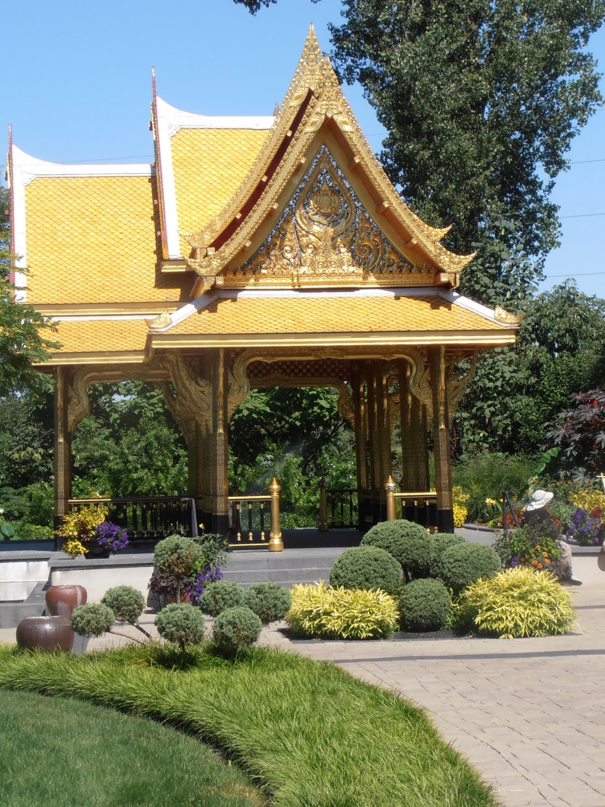
The big visit of the trip was to the Olbrich Botanical Gardens in Madison.  The gardens are relatively compact at a total of 16 acres, with lots and lots of features.  The highlight is the Thai Pavilion, a donation from the Thai government and Thai alumni of the University of Wisconsin.  It was built in Thailand, dismantled, shipped to Wisconsin, and then assembled and completed by Thai artisans in 2002.  The teak in the structure withstands the Wisconsin winters, but the gold leaf has to be removed each winter and reapplied each spring.  Here it is:


The Olbrich is a public garden owned by the City of Madison and operated by it in partnership with the non-profit Olbrich Botanical Society.  It is part of a large park on the shore of Lake Monona.  The property belonged to Michael Olbrich, a lawyer who was a disciple of Robert LaFollette, the progressive Republican senator and presidential candidate.  He offered to donate the land to the city to be named "Robert LaFollette Park", but the offer was refused because of objections to the name due to LaFollette's opposition to World War I.  Olbrich later donated the land without requiring the association to LaFollette.

Construction of the botanical gardens did not start until 1970, and it has developed gradually since then based on availability of private grants and fundraising activities.  It has been the subject of four master plans, the most recent of which was adopted in 2000.

Here are some features I particularly liked:

Julie, Michael and Amanda
In Front of the Sunken Garden

The Rock Garden, which highlights various dwarf evergreens.  (The Missouri Botanical Garden in St. Louis has a very similar feature):


I think these are False Chamomile, but I'm not sure.  If they are, they are the seed pods of an aster:


Water Lily:


Dinnerplate-sized hibiscus in the perennial garden:


Our last stop on the trip was at the Table Fifty-Two restaurant in Chicago.  I don't know what was the bigger treat, eating southern cooking in a gourmet restaurant, or eating southern cooking in Chicago.  We went at the recommendation of my niece Elizabeth, who is our own professional chef and taste expert.  The food and its presentation were outstanding.  I ate fried catfish with grits, collard greens and a hushpuppy.  Julie had fried green tomatoes and pistachio-crusted chicken breast.

Tuesday, August 2, 2011

Jasper National Park, AB to Calgary, AB

Same-O, same-O.  Refer to the tab for "Rockies"

Mileage: 248.  Cumulative mileage: 10,077

Monday, August 1, 2011

Edmonton, AB to Jasper National Park, AB

I spent three days in the Canadian Rockies.  The pictures are extensive, and are under the separate tap of "Rockies".

Mileage: 333.  Cumulative mileage: 9,829

Sunday, July 31, 2011

Great Falls, MT to Edmonton, AB

Driving through Southern Alberta Province I passed thousands of acres of fields of yellow—a yellow-flowering plant about the height of soybeans.  I had never seen this crop before.  It is rapeseed, which is the source of canola oil.  Common or wild rapeseed is high in erucic acid, which makes it suitable for use as a biodegradable lubricant and as a binder for oil paints.  A hybrid form of rapeseed has been developed that is low in erucic acid that makes it suitable for human consumption and for use as livestock feed.  In 1978 the term “canola” was devised to stand for “Canadian oil, low acid.”

According to Wikipedia, canola oil is low in saturated fat, high in monosaturated fat, and it has a beneficial Omega-3 profile.  Hybrid rapeseed is grown in the provinces of Alberta, Saskatchewan and Manitoba.  Also, all production in the United States is in North Dakota.  It is also the third largest crop in Australia, although its uses there are limited to non-food products.  In the past ten years world production of canola has quadrupled.

The yellow fields look a lot like fields of mustard, as you might see growing wild in California.  That is not surprising since both rapeseed and field mustard belong to the genus Brassica.


Rapeseed Field in Alberta,
Used in the Production of CANOLA
Mileage: 530.  Cumulative mileage: 9,496

Saturday, July 30, 2011

Miles City, MT to Great Falls, MT

Over the past two days I have traveled gradually up in elevation as I have crossed the upper Great Plains and have approached the Rocky Mountains from the East.  Most of the trek consists of rolling hills composed of deep sedimentary rocks from Cretaceous Period, 146 to 66 million years old.  This was the height of the Age of Dinosaurs, up to the point of their extinction.  The sediment itself was the result of a shallow sea that covered the middle of the North American continent during much of this period.  Thus, most of the landscape consists of relatively 'young' rocks that have been subject to some uplift, but not to tectonic and volcanic activity.  The gradual elevation change is due to the uplift of the Rockies, which came from land shifts originating on the western side of the mountains.

I found the landscape quite beautiful and varied.  It appeared green and lush, particularly for July.  Here were the great fields of grain, alone with corn and soy.  Land unsuited for crops was used for cattle range.  And there were areas with trees, particularly along the river valleys and stream beds.

As I approached the Rockies I got my first glimpses of Precambrian rocks, igneous and metamorphic, capped by the thin overlay of Cretaceous sandstone.  These pictures were taken in central Montana, just south of Great Falls:


My objectives in Great Falls were to see the Lewis & Clark Expedition Interpretive Center, Giant Spring and the Roe River, and the Charles Russell Museum.  I did them all this afternoon.

Great Falls was a major event on the Lewis & Clark Expedition because it involved a portage up over the falls that took almost two weeks to accomplish.  There are interpretive centers at several sites along the expedition trail.  This one is operated by the National Park Service and is quite extensive.  As you walk through the exhibition, one side tells the story of the expedition and the other side tells about the Indians that occupied the land along the route.  It is very nicely done.

Here are the pictures from the Charles M. Russell Museum:

Charles M. Russell


Charles M. Russell

Exhibit at Charles M. Russell Museum

Exhibit at Charles M. Russell Museum

Exhibit at Charles M. Russell Museum

Exhibit at Charles M. Russell Museum


Charles M. Russell


Charles M. Russell


Charles M. Russell

Mileage: 388.  Cumulative mileage: 8,966.